Intertropical Convergence Zone (ITCZ)

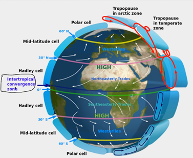
Intertropical Convergence Zones or Doldrums are areas of low pressure around the Equator where Trade Winds converge, is a straightforward climatic pattern but most of the people confuse it with the Equator, it is not the Equator but something more than that. See in the figure, when Northeasterly Trade winds and Southeasterly Trade wind converge they form a region of low pressure which is not precisely situated at 0-degree latitude, there is some latitude difference between ITCZ and the Equator. If you see a satellite image of the Earth, there is a linear pattern of clouds near the Equator, and these are the clouds above ITCZ because when Northeasterly Trade wind and Southeasterly Trade winds converge. Because of heat, the air rises, and it leads to cloud formation.

Often we assume the Equator gets heated most, this concept is not always real, on an average Equator receives most heat. The Axis of rotation of Earth is not straight it is tiled at the angle of 23.5 degrees if the Axis of rotation is not tilted the Equator would always be the outermost latitude of the Earth with respect to Sun and Equator should get heated most every time. However, this is not the case as the rotation axis is not vertical but tilted. Because of inclination of rotation axis latitudes are not horizontal, they are also tilted at the same angle. As a result of this, when Sunlight reaches the Earth, the Equator is not closest to the Sun. See in the figure, the closest latitude is tropic of cancer (23.5 degrees north latitude) during summer in the northern hemisphere, and same for tropic of Capricorn (23.5 south latitude) during summer in the southern hemisphere, this is the reason that ITCZ shifts towards the north during summer in northern hemisphere and shifts in the south during summer in the southern hemisphere.

So, the ITCZ does not follow the Equator or any other latitude; it follows the low-pressure zone where the Earth receives most heat from the Sun. ITCZ is not any fixed line or pattern. The position of ITCZ also varies with seasons; the variation depends upon regional heat and pressure conditions. Near the pacific ocean and America variation is not much as compared to variation near India, ASEAN or Australia, Maximum it can shift up to 25 degrees north latitude and 20 degrees south latitude. As ITCZ follows low pressure and high surface temperature, the surface temperature can be sea temperature of land temperature. Land heats up faster than the ocean. In northern hemisphere land is more, this is the reason that in the northern hemisphere it moves more northwards as compared to movement in the southern hemisphere. Over the see variation of ITCZ is minimum, and it is near to the Equator on the other hand on continents, or subcontinents like Africa, India or Australia deviation is significant.
In the Indian context, ITCZ is located in northern India during summers, which creates a low-pressure zone; this low pressure attracts the monsoon. In winter it shifts below the Equator.
